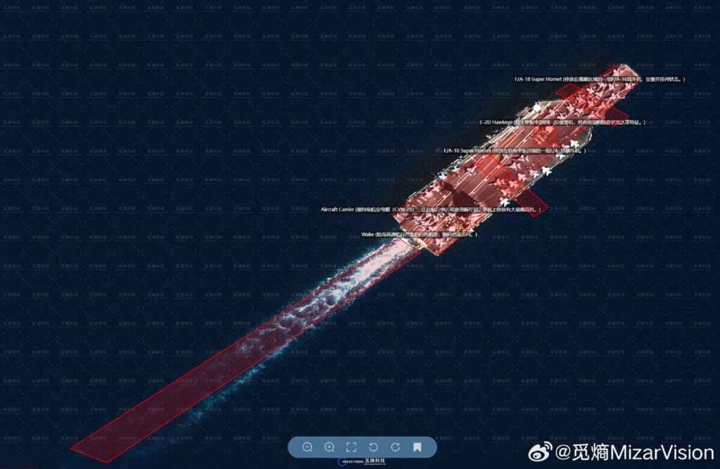
A U.S. aircraft carrier leaves port. Hours later, annotated satellite images appear online. The ship is identified, the route marked, the timing dissected.
Who is watching?
China is. And it is doing so largely through OSINT — Open Source Intelligence — by combining commercial satellite imagery, flight tracking data, maritime signals and social media analysis.
Military intelligence no longer lives only behind classified doors. It now unfolds in public feeds.
Why the Gulf Has Become a Digital Observation Zone
The Gulf is a strategic corridor. U.S. naval forces rotate through regional ports. Air assets deploy to bases across the Middle East. Logistics aircraft connect continents.
Every movement leaves a trace.
Recent satellite images circulating on X have shown:
- A U.S. aircraft carrier departing Souda Bay
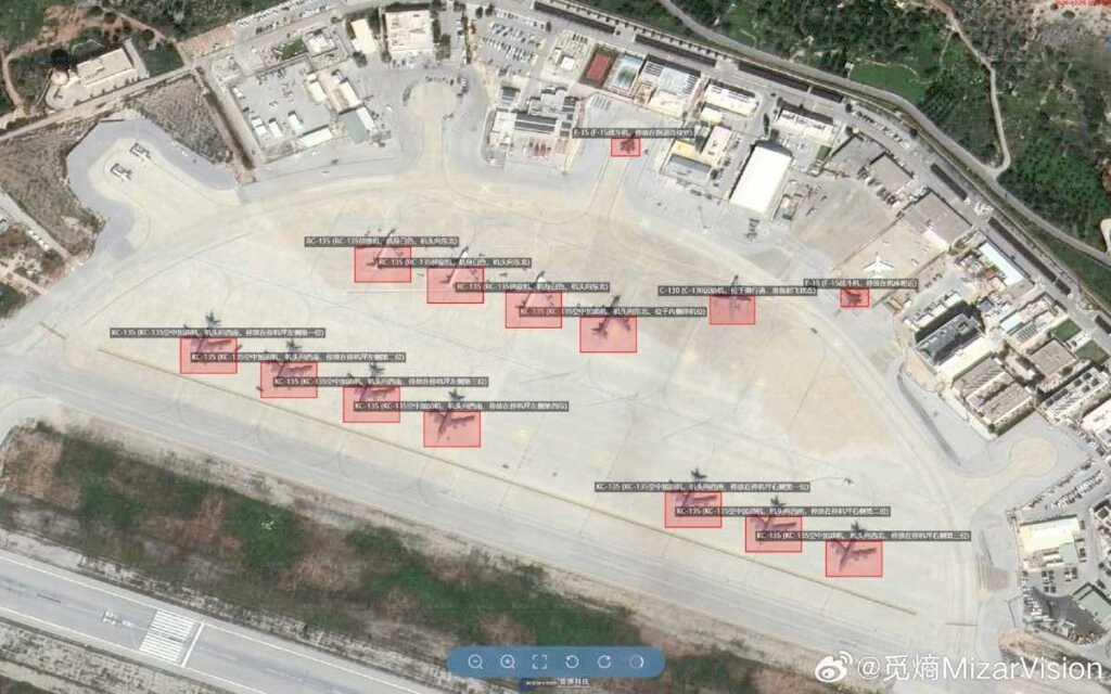
- Fighter aircraft repositioned to regional bases
- Transport and refueling planes landing in Diego Garcia
- Changes in airfield activity across Saudi Arabia
Each visual, taken alone, looks routine.
Placed in sequence, they reveal operational tempo.
The Mechanics of Military OSINT
Military OSINT is not guesswork. It follows a method.
First, analysts monitor high-interest locations: ports, air bases, chokepoints.
Second, they acquire updated commercial satellite imagery.
Third, they compare changes over time.
Fourth, they cross-check with flight tracking platforms and maritime AIS signals.
Fifth, they annotate and publish.
The process is technical but not classified.
Commercial satellite providers sell high-resolution imagery globally. Flight data platforms track aircraft transponders. Maritime databases show ship routes. When combined, they produce a near real-time map of military posture.
From Hobbyist Tracking to Strategic Signaling
At first glance, social media accounts sharing annotated images look like independent enthusiasts.
Look closer.
Many posts show structured analysis. Aircraft types are labeled. Runway positions measured. Support vehicles identified. Patterns documented over weeks.
This is not casual observation.
It is strategic monitoring conducted in the open.
Publishing these visuals also carries a message:
We see you. We understand your posture.
Visibility becomes deterrence.
What Beijing Gains from Watching
Monitoring U.S. deployments in the Gulf offers several advantages.
It reveals force projection capacity.
It exposes logistics depth.
It shows reaction speed during regional crises.
For Chinese analysts, this data also holds indirect value beyond the Middle East. Observing how Washington coordinates naval groups, air defense systems and long-range logistics provides lessons applicable to other theaters.
Military patterns travel.
Doctrine leaves fingerprints.
The Role of Commercial Satellite Imagery
A decade ago, satellite intelligence was largely state-controlled.
Today, private companies sell imagery detailed enough to distinguish aircraft models and ship classes. Revisit rates are faster. Archive comparisons are easier.
Analysts can:
- Track a carrier strike group over days
- Identify new missile defense deployments
- Count transport aircraft during surge operations
- Detect damage at airfields after strikes
Images are timestamped. Changes are measurable.
No classified clearance required.
Is This Legal?
Open Source Intelligence relies on publicly accessible data. Commercial satellite imagery is legally purchasable. Flight tracking platforms aggregate transponder signals. Maritime AIS data is publicly transmitted.
The legality is clear in most jurisdictions.
The consequences are more complex.
Public tracking narrows operational secrecy. It accelerates geopolitical signaling. It amplifies tension during crises.
Transparency reshapes strategy.
Strengths and Limits of Military OSINT
OSINT delivers speed.
It enables cross-verification.
It reduces reliance on leaks.
Yet it has blind spots.
Satellite images show presence, not intent.
Aircraft counts reveal capacity, not decisions.
Data can be misread.
Disinformation can be inserted deliberately.
An image is evidence. It is not context.
The Information Battlefield
Modern military competition includes perception management.
When satellite images circulate widely, narratives form quickly. Analysts interpret deployments before governments release statements. Online debate precedes official briefings.
The battlefield extends beyond geography.
States move forces.
Observers move narratives.
Audiences draw conclusions.
OSINT sits at the center of that dynamic.
Why This Matters Now
Global crises unfold faster than ever. Carrier deployments, airlifts and missile defense shifts trigger diplomatic ripples within hours.
Open-source monitoring compresses reaction time.
Governments must assume their movements will be observed and interpreted almost immediately.
The era of quiet repositioning is fading.
Final Takeaway
China’s monitoring of U.S. military movements in the Gulf highlights a structural shift in intelligence.
OSINT is no longer peripheral. It is embedded in geopolitical competition.
Commercial satellites, open data platforms and social media analysis have created a world where military posture becomes visible in near real time.
Intelligence has not become less important.
It has become more public.
Want to master military OSINT techniques?
Explore our in-depth guides on satellite analysis, geolocation and digital verification on https://projectosint.com/.
Subscribe to the newsletter:
https://projectosint.substack.com/
Join the Telegram communities:
https://t.me/osintprojectgroup
The next strategic move may appear first as a pixel.
Photo by @MizarVision