When Images Start Talking: AI and the Strait of Hormuz Crisis
In early March 2026, a geopolitical crisis unfolded in one of the world’s most sensitive energy corridors: the Strait of Hormuz. Oil tankers stopped moving. Markets reacted instantly.
But the first clear picture of the situation did not come from a press conference.
It came from a combination of satellite images, metadata, and AI-driven news analysis.
This moment highlights a major shift in digital intelligence: news is no longer analyzed through text alone. Artificial intelligence now processes images, geolocation data, and visual signals at the same time.
The result is a new investigative layer often described as multimodal AI news analysis.
The Strait of Hormuz: A Strategic Chokepoint


The Strait of Hormuz handles one of the largest flows of oil on the planet. Any disruption quickly ripples across the global economy.
During the 2026 crisis:
- Oil shipments dropped sharply.
- Tanker traffic collapsed.
- Energy markets reacted within hours.
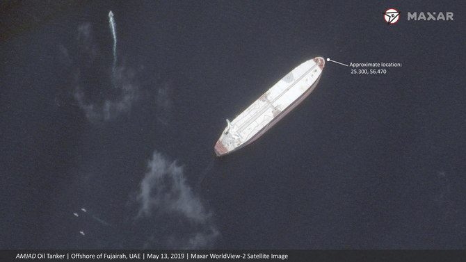
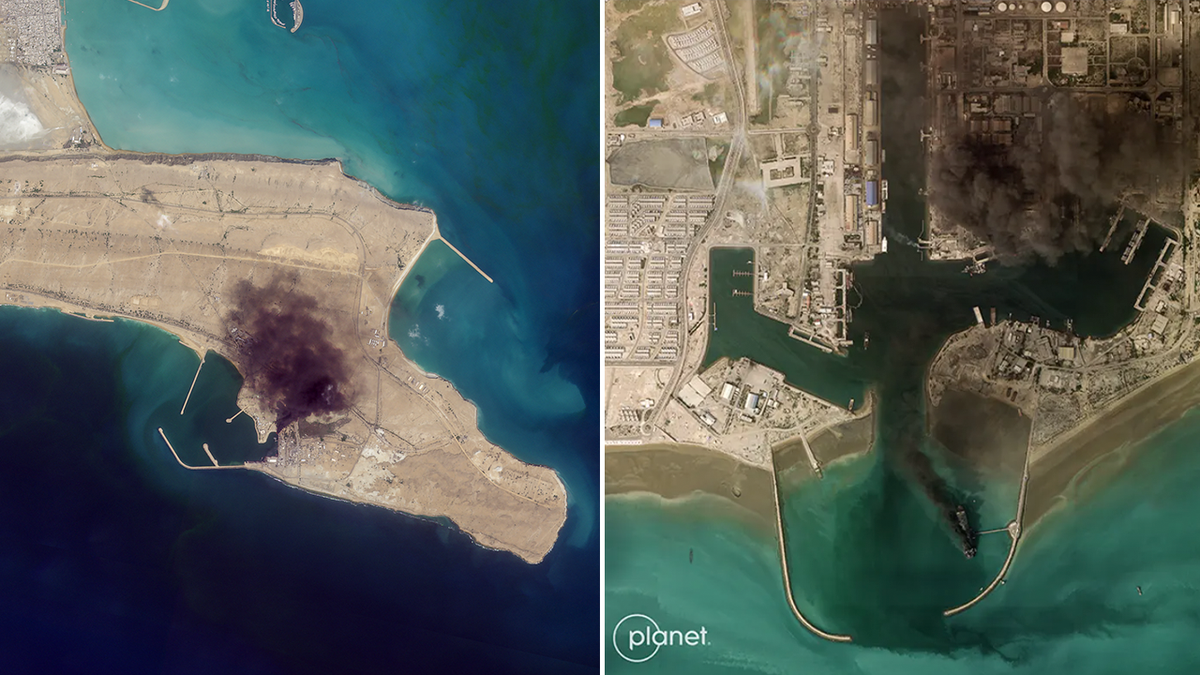
Satellite imagery confirmed the scale of the disruption. Traffic through the Strait fell from roughly 100 vessels per day to fewer than five.
At the same time, reports indicated that 17 tankers had already been struck, turning a political standoff into a logistical shock for global energy supply.
Traditional reporting explained the political context.
Images revealed the physical reality.
The Emergency Oil Release: A Temporary Fix
The International Energy Agency (IEA) announced the largest coordinated oil reserve release in history: 400 million barrels.
At first glance, the measure sounded massive.
The math told another story.
The closure of the Strait removed around 15 million barrels per day from global supply. The IEA could release 2–2.5 million barrels daily.
That left a deficit exceeding 10 million barrels per day.
Markets understood the gap immediately. Brent crude rose 4.76% to $91.98 on the day of the announcement.
One analyst compared the measure to “pouring water into a leaking barrel.”
The reserves bought time for diplomacy, not a structural solution.
Where Artificial Intelligence Entered the Picture
The real innovation in this case did not come from oil markets. It came from AI-assisted news analysis.
A system called Image Context processed news coverage by combining:
- article text
- satellite imagery
- press photography
- visual metadata
- geographic coordinates
The platform automatically extracted details from images:
who appeared in the picture, what objects were present, where the photo was taken, and which entities were involved.
This allowed analysts to connect visual evidence with written reporting in a single query.
Instead of reading hundreds of articles manually, investigators could analyze events through both words and images.
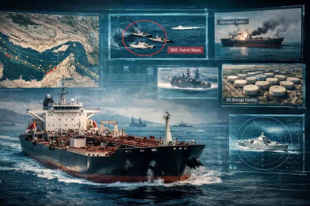
What Images Revealed That Text Missed

Visual analysis uncovered details that ordinary text searches rarely surface.
Satellite confirmation of tanker damage
Image metadata identified vessel types and geographic coordinates automatically.
Naval deployment patterns
Press photographs containing military vessels revealed deployment patterns linked to Iranian naval forces.
Some articles never mentioned those vessels explicitly.
The images did.
Storage saturation risks
Photos of oil storage facilities in Iraq and Kuwait pointed to another concern: storage capacity was approaching its limits.
Text reports focused on policy decisions.
Images exposed the physical logistics behind them.
Political signals hidden in photos
Emergency press conferences also provided clues.
AI tagging identified political figures, including energy officials and heads of state. Facial expressions and staging added context that headlines flattened.
Images rarely lie. They just require interpretation.
Cross-Modal Search: A New OSINT Capability
Multimodal AI makes one key change: search no longer depends on text alone.
A query such as:
“IRGC fast attack boats Strait of Hormuz”
can now return articles where:
- the vessels appear only in photos
- the text never mentions their class
- metadata identifies the boat visually
The system extracts:
- vessel types
- coordinates
- military insignia
- geographic location
and links them to the article automatically.
For OSINT analysts, this capability removes hours of manual work.
Before tools like this, analysts had to:
- scrape article HTML
- download images
- run separate vision models
- connect results back to the text
Now a single API request can return text analysis and visual intelligence together.
Why Multimodal Intelligence Matters for OSINT
The Strait of Hormuz episode illustrates a broader transformation.
Open-source intelligence increasingly relies on multiple data layers:
- satellite imagery
- geolocation metadata
- social media images
- news archives
- shipping and logistics data
Text analysis alone cannot reconstruct complex geopolitical events.
Multimodal AI changes the workflow.
Investigators gain:
- faster verification of incidents
- geographic correlation of events
- automated identification of objects and actors
- searchable visual archives
For journalists and analysts, this shortens the distance between raw evidence and interpretation.
The Limits of AI-Driven News Intelligence
The technology remains powerful but imperfect.
Visual analysis still faces several limitations.
Context ambiguity
An image may show a damaged tanker.
The cause may remain unknown.
Source reliability
Satellite imagery from different providers may vary in quality and timestamp accuracy.
Political interpretation
Visual evidence can still be framed selectively by governments, media outlets, or analysts.
AI can surface patterns.
Human judgment must still interpret them.
A Glimpse of the Future of Investigative Journalism
The Strait of Hormuz crisis offers a preview of how investigative reporting is evolving.
The next generation of newsroom analysis will combine:
- AI text processing
- satellite intelligence
- geospatial mapping
- image recognition
Stories will increasingly emerge from data correlations across different media types, not from documents alone.
In other words, journalism is moving closer to the methodology long used in intelligence analysis.
Want to Explore This Field Further?
If AI-driven OSINT and multimodal news analysis interest you, start experimenting with tools that combine:
- satellite imagery
- image recognition
- geolocation extraction
- cross-modal search
The next major investigation may not begin with a headline.
It may begin with a satellite photo that an algorithm noticed before anyone else did.
Join the OSINT & AI community
Newsletter: https://projectosint.substack.com/
Telegram: https://t.me/osintaipertutti
Telegram: https://t.me/osintprojectgroup